Property Record
2370 Danielsville Rd, Athens, GA 30601
NEARBY LISTINGS FOR SALE OR LEASE
-
-
View all Athens listings for sale on LoopNet.com
Property Detail
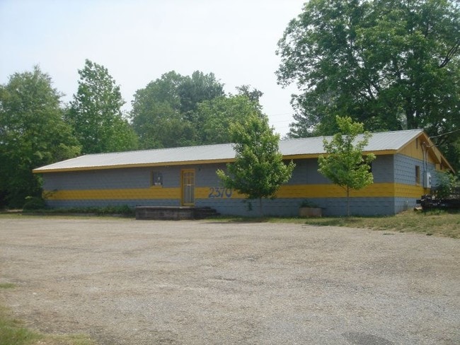
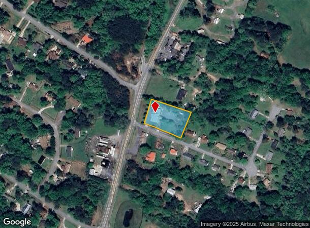
2370 Danielsville Rd
Athens-Clarke County, GA
Com-St-034->00-03
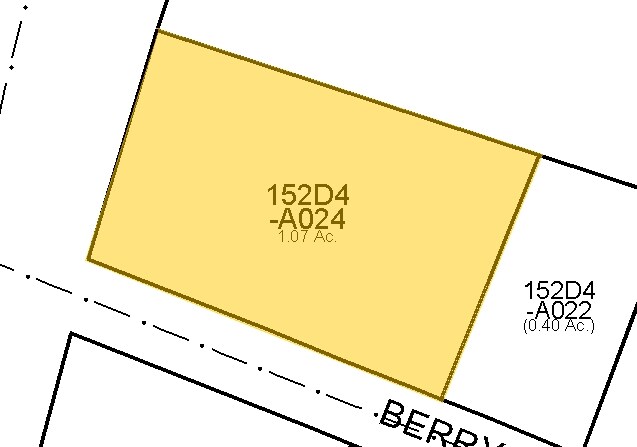
152D4-A-024
LOT: 1-2 ;
Religious
Clarke
X
Georgia
13059C0007E
1,2
0
1.07 AC
2025
North Athens
140400
Other Market Areas
3,461 SF
DEMOGRAPHICS near 2370 Danielsville Rd
1 Mile
3 Mile
5 Mile
2024 Total Population
2,633
13,604
54,435
2029 Population
2,646
13,988
55,710
Pop Growth 2024-2029
+ 0.49%
+ 2.82%
+ 2.34%
Average Age
37
37
34
2024 Total Households
901
5,125
20,472
HH Growth 2024-2029
+ 0.78%
+ 2.63%
+ 2.19%
Median Household Inc
$49,970
$46,922
$41,840
Avg Household Size
2.80
2.60
2.40
2024 Avg HH Vehicles
2.00
2.00
2.00
Median Home Value
$83,717
$133,151
$186,823
Median Year Built
1994
1991
1986
Nearby Places
Map Layers
Map Styles
 Street
 Aerial
- Restaurants
- Banks
- Shops
- Fitness
- Groceries
Nearby Properties
Address
Land Use
TOTAL SIZE
Lot Size
Zoning
Address
Land Use
TOTAL SIZE
Lot Size
Zoning
1,403 SF
21.64 AC
C-G
Address
Land Use
TOTAL SIZE
Lot Size
Zoning
3.16 AC
E-I
Address
Land Use
TOTAL SIZE
Lot Size
Zoning
2,856 SF
39.78 AC
C-G
Address
Land Use
TOTAL SIZE
Lot Size
Zoning
124,959 SF
20.54 AC
E-I
Address
Land Use
TOTAL SIZE
Lot Size
Zoning
2,880 SF
36.84 AC
RM-1
Address
Land Use
TOTAL SIZE
Lot Size
Zoning
3,628 SF
6.57 AC
RM-2
Address
Land Use
TOTAL SIZE
Lot Size
Zoning
140,375 SF
26.15 AC
E-I
Address
Land Use
TOTAL SIZE
Lot Size
Zoning
Address
Land Use
TOTAL SIZE
Lot Size
Zoning
9,600 SF
12.71 AC
RM-2
Address
Land Use
TOTAL SIZE
Lot Size
Zoning
14,000 SF
42.62 AC
E-I
Address
Land Use
TOTAL SIZE
Lot Size
Zoning
4,392 SF
11.79 AC
C-G
Address
Land Use
TOTAL SIZE
Lot Size
Zoning
26,100 SF
18.59 AC
C-G
Address
Land Use
TOTAL SIZE
Lot Size
Zoning
71,472 SF
43.36 AC
E-I
Address
Land Use
TOTAL SIZE
Lot Size
Zoning
262,387 SF
16.45 AC
E-I
Address
Land Use
TOTAL SIZE
Lot Size
Zoning
47,928 SF
80.47 AC
E-I
Address
Land Use
TOTAL SIZE
Lot Size
Zoning
36.93 AC
G
Address
Land Use
TOTAL SIZE
Lot Size
Zoning
11,520 SF
5.03 AC
RM-2
Address
Land Use
TOTAL SIZE
Lot Size
Zoning
124,136 SF
19.82 AC
C-G (PD)
Address
Land Use
TOTAL SIZE
Lot Size
Zoning
136,460 SF
13.27 AC
C-G
Address
Land Use
TOTAL SIZE
Lot Size
Zoning
18.38 AC
G
Address
Land Use
TOTAL SIZE
Lot Size
Zoning
67,768 SF
40 AC
E-I
Address
Land Use
TOTAL SIZE
Lot Size
Zoning
15.34 AC
G
Address
Land Use
TOTAL SIZE
Lot Size
Zoning
258,200 SF
16.49 AC
E-I
Address
Land Use
TOTAL SIZE
Lot Size
Zoning
16.63 AC
G
Address
Land Use
TOTAL SIZE
Lot Size
Zoning
327,319 SF
24.46 AC
E-I
Address
Land Use
TOTAL SIZE
Lot Size
Zoning
8,664 SF
103.89 AC
E-I
Address
Land Use
TOTAL SIZE
Lot Size
Zoning
2,187 SF
46.64 AC
RM-1
Address
Land Use
TOTAL SIZE
Lot Size
Zoning
222,180 SF
17.08 AC
E-I
Address
Land Use
TOTAL SIZE
Lot Size
Zoning
16.17 AC
G
Address
Land Use
TOTAL SIZE
Lot Size
Zoning
13,320 SF
60.89 AC
C-G
The World's #1 Commercial Real Estate Marketplace
Connect with us
© 2025 CoStar Group
The information above has been obtained from sources believed reliable. While we do not doubt its accuracy we have not verified it and make no guarantee, warranty or representation about it. It is your responsibility to independently confirm its accuracy and completeness. Any projections, opinions, assumptions, or estimates used are for example only and do not represent the current or future performance of the property. The value of this transaction to you depends on tax and other factors which should be evaluated by your tax, financial, and legal advisors. You and your advisors should conduct a careful, independent investigation of the property to determine to your satisfaction the suitability of the property for your needs.